
Flash flooding, high winds, hail, and brief landspout tornadoes are forecast in parts of Colorado Saturday.
A Severe Thunderstorm Watch was issued for Fort Collins, Sterling, Fort Morgan, Longmont, Denver, Colorado Springs, Pueblo, La Junta, Lamar, and surrounding areas Saturday until 9 p.m. The thunderstorm watch includes
Adams, Arapahoe, Bent, Cheyenne, Crowley, Elbert, El Paso, Kiowa, Kit Carson, Lincoln, Logan, Morgan, Otero, Phillips, Prowers, Pueblo, Sedgwick, Washington, Weld, and Yuma counties in Colorado.
A severe thunderstorm watch has been issued for parts of Colorado and Nebraska until 9 PM MDT pic.twitter.com/ETDbQZTs1M
— NWS Pueblo (@NWSPueblo)
The watch warns of lime-sized hail, wind gusts up to 75 mph, and frequent lightning.
Severe storms possible over Pueblo County over the next 1.5 hours. Now through 3:30PM. Main concerns are 60mph wind gusts and 1″ hail. #COwx #Colorado pic.twitter.com/w7IhikjR3G
— NWS Pueblo (@NWSPueblo)
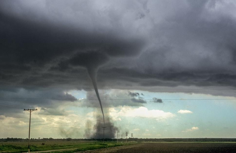
Elbert, Lincoln, east Adams, and Arapahoe counties have a chance of brief landspout tornadoes, the weather service said.
Meteorologists detected around 1:30 p.m. weather conditions were becoming likely to produce a tornado. Landspout tornadoes form with developing thunderstorms before rain, hail, or thunder is present.
Thunderstorms continue to move across the eastern side of the Denver metro. Gusts up to 50 mph will be possible with this storm, along with lightning! #cowx https://t.co/oAzhQt6fY4
— NWS Boulder (@NWSBoulder)
These tornadoes are not typically associated with a wall cloud, making them difficult to detect on radar, the weather service said.
At about 2:30 p.m., a landspout tornado was reported south of Wiggins, a town in northeast Colorado.
Here is a video of the landspout which prompted the tornado warning. It has since lifted. Additional landspout tornadoes will be possible over the next hour or so if additional storms form along this boundary. #cowx https://t.co/ESQyVdPBMR
— NWS Boulder (@NWSBoulder)
The National Weather Service issued a Flash Flood Watch for burn scars in southern Colorado until 10 p.m. The watch covers areas including the Decker, Junkins, and Hayden Pass burn scars.
Half-inch hail and winds up to 40 mph are expected for Fremont County Saturday afternoon.
In Teller County and the immediate areas of the Pikes Peak region, penny-sized hail and winds of 40 mph are forecast.
Other areas included in the forecast are southwestern Colorado Springs, Fountain, Fort Carson, Stratmoor, Security, and Security-Widefield.
Half-inch hail and wind gusts of 50 to 55 mph will be possible with storms over Glenwood Springs, Rifle, New Castle, Silt, Parachute, and Battlement Mesa.
This area includes the portion of Interstate 70 in Colorado between mile markers 63 and 121.
Weather conditions are subject to change. Check with the National Weather Service for updated information on weather and with Colorado Department of Transportation on road closures and conditions.
This content was originally published here.