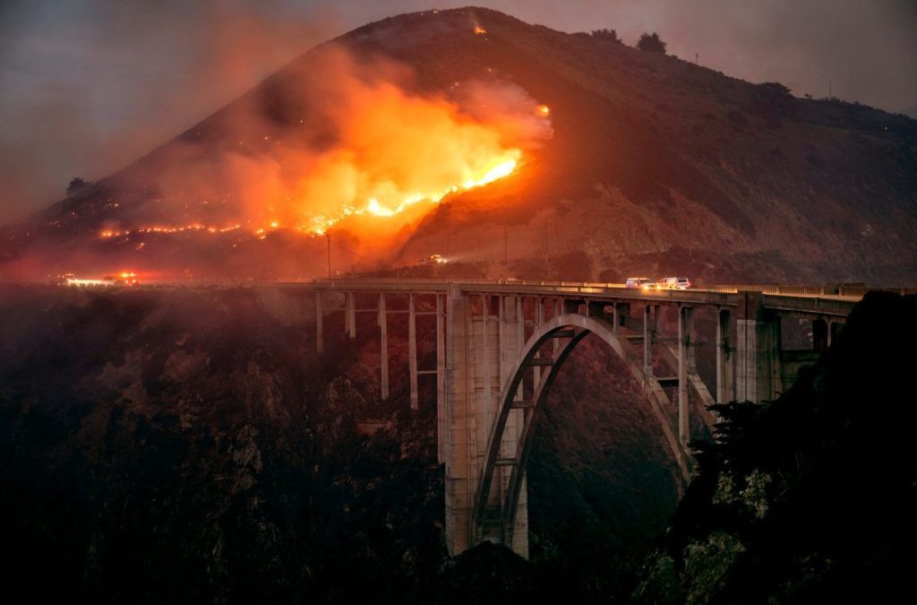
BIG SUR – A rare winter wildfire that started near the Big Sur coast burned to the edge of the famed Bixby Bridge Saturday, closing California’s scenic Highway 1 and forcing people living in rugged back canyons to flee.
The wind-driven Colorado Fire that burned 1,050 acres of mostly coastal chaparral had calmed as winds died late Saturday morning, and by Saturday evening, Cal Fire said the blaze was about 20% contained. Initial reports from the fire agency said more acreage had burned, but better mapping led to a changed figure later Saturday.
Despite dramatic flames that lit up the night sky Friday and a glow that could be seen for miles, no injuries were reported, though one structure was reported damaged.
“People say, ‘well it rained,’ but it’s not enough rain,” said Mark Courson from the state’s Office of Emergency Services, while standing on the edge of Highway 1 Saturday. “Throw wind on it and all bets are off.”
Friday’s fire in the Big Sur region comes less than a month after a devastating wildfire in the state of Colorado burned more than 500 homes, the latest example of what has become a year-round fire season in the Western states, driven in part by global warming.
Although Monterey County rainfall is still 118 percent of average, thanks to rains through December, there has been no measurable rain here in January, according to the National Weather Service. The chaparral on the steep mountainsides of Big Sur dry out quicker than forests and are more susceptible to catch fire, said meteorologist Jan Null of Golden Gate Weather Services.
“Some of it is carryover from the drought of the last two years,” Null said of the fire, “and the ‘flash-burn’ types of fuels that seem to be in this area.”
In the Bay Area, the winds that gusted to 40 mph and spread the Colorado Fire were even stronger in the Oakland Hills, toppling trees and leaving nearly 30,000 customers without power Saturday morning.
Wildfires are unusual in California this time of year. Since 2013, Cal Fire has battled only 20 fires that broke out during January, and in four of the years there weren’t any.
In Big Sur, however, Fire Chief Harris remembers the “very destructive” Pfeiffer Fire in December 2013 that burned more than 900 acres and destroyed 22 structures and 14 homes along Pfeiffer Ridge Road.
Evacuation orders shocked those forced to flee Friday. Rachel Meuller, who lives at the mouth of the canyon close to the highway, was one of them, leaving her home with her husband at about 8 p.m..
“My neighbor called to say someone up the canyon could see the flames. We didn’t believe it,” said Meuller, waiting with other evacuees at a roadblock near Garrapata on Saturday to try to return to their homes. Quickly, though, “I could see the flames coming over the ridge right behind us. It was terrifying. We got in the car as far as we could.”
The Colorado Fire broke out at 5:19 p.m. Friday in the Palo Colorado Canyon and Rocky Creek Road area in Monterey County. Wind gusts drove it to the edge of the Pacific Ocean. Videos show the fire burning down to Rocky Creek Bridge as well as the historic Bixby Bridge. Built in 1932, the Bixby Bridge’s iconic arch supports and dramatic views of rugged coastline are so popular that luxury car commercials are made here and tourists taking selfies routinely cause traffic jams. The fire caused no damage to the structure.
Although the Colorado Fire started near the coast, the fire became aligned with fast-moving winds blowing in both directions and “made a run through the canyons,” Cal Fire Assistant Chief George Nunez said in an interview.
“It moved surprisingly fast for a fire around this time of year,” said Nunez, who works in Cal Fire’s San Benito-Monterey unit. “We had a little bit of moisture and it was cold last night, but because of the winds, it burned along the slope, caught another wind and then blew in another direction.”
The dramatic Big Sur coastline is a frequent victim of natural disasters, from fires to landslides that often close Highway 1, cutting off tourists from Los Angeles and the Bay Area that frequent the cliffside restaurants and redwood-studded campgrounds.
The highway closure spanned from near the Andrew Molera State Park entrance area in Big Sur to Rio Road in Carmel, according to Caltrans District 5. By late Saturday morning, the closure was moved to eight miles south of Rio Road.
Three weeks of dry conditions along with strong winds will “definitely carry a fire,” said National Weather Service meteorologist Roger Gass said.
“The winds have relaxed and the firefighter effort was strong today. That’s some good news,” Gass said. “We’re not likely to see this turn into 30,000 or 100,000 acres like we see at the peak of our fire seasons. There’s still moisture in the ground.”
Father Cyprian Consiglio, a monk at the New Camaldoli Hermitage, felt fortunate to be outside the fire zone – this time. During the Dolon Fire in August 2020, he and 13 fellow monks and 14 staff evacuated the hermitage for a month.
Related Articles
Jim Kearns, whose home overlooks the Pacific Ocean in Garrapata, said he saw emergency vehicles heading south along Highway 1 while he drove home from Monterey on Friday night.
“I thought there was an accident on the road and I came around the corner and saw the glow,” he said. “You don’t expect it to happen because it’s so green.”
Staff writers Shae Hammond and Harriet Rowan contributed to this story.
Staff writer Joseph Geha contributed to this report.
This content was originally published here.

