
When Colorado Parks and Wildlife began working last fall to add a new functionality to its COTREX trail app that would track closures around the state this spring, there was no COVID-19. The idea was to improve the app by tracking common closures due to things like muddy trails and trailhead construction projects.
It’s live now, and that’s timely because of increased use of trails and open spaces by people seeking to get out of the house for outdoors recreation, even as trails may be closed for social distancing considerations. Users can click on an area of the state and see closures or alerts covering trails, trailheads and other closures related to those trails. The app is free to users.
“People have been looking to websites and blog posts to find out what the latest trail condition is,” said Alex Alma, trails and recreation project manager for the Colorado Department of Natural Resources. “We’re trying to step into that space to provide up-to-the-second information.”
The app includes information about trails on federal land — national parks, forests, the Bureau of Land Management and U.S. Fish and Wildlife — as well as Colorado state parks and county open spaces.
“We’re at an interesting time because we’re still under the stay at home order, looking to transition into safer at home,” Alma said. “As stuff starts to open back up, we want to have a platform for people to know where they should be going, because as we start to work with counties and other land managers about different strategies and some local control, we want to make sure the public knows where it is safe to recreate responsibility.”
Users can tap into COTREX via apps on their phones or through a computer web browser. After the app opens, users can zoom into the area where they are looking to recreate to find out what closures or alerts may be in effect. Then you can click on the closure or alert for more details.
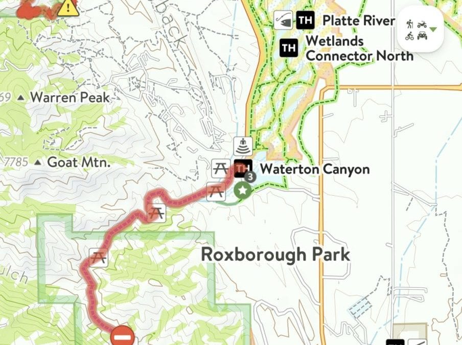
For example, there is a current alert at the bottom of the Nightbird Gulch trail on Mount Galbraith, just north of Golden, indicating that trail is for “Neighborhood access only” until further notice. Tapping on Waterton Canyon near Chatfield Reservoir opens an alert that says access was closed March 18 until further notice because of COVID-19.
The free app, which currently has about 32,000 user accounts, went live in the fall of 2018 and is funded by grants from Great Outdoors Colorado. It cost about $500,000 to develop and requires about $50,000 annually to maintain.
“The cost is well worth it,” Alma said. “We’re having active conversations with a lot of land managers that are trying to make closures in response to COVID. We have this functionality now, so we’re going to be pretty busy the next few weeks, bringing on more land managers. We’re just thankful that it is free and we don’t have to do sponsorships, advertisements, (or) paid subscriptions like some of the other trail apps. We’re thankful for that source and being able to provide this good public service.”
CPW has been tracking changes and updating the app to keep it as up-to-date as possible. It’s in the process of “handing over the keys” to land managers via a dashboard they can use to input their own information in real time,” Alma said.
“We started with the big federal land managers with one-on-one coordination calls,” Alma said. “We’ve been working with them to identify the resources they are using. They have alert pages, and we’re monitoring those on a daily basis, doing our best to put in updates. Right now we’re focusing a lot on those Front Range open space programs that are getting hit pretty hard with activity because of COVID.”
This content was originally published here.