Mount Antero is often avoided by many peak baggers – there’s only one established route to the top and approximately fifteen of sixteen miles consist of traveling a four-wheel-drive road. The length coupled with the lack of classic trail make this peak far less appealing to summit in the eyes of many, though that shouldn’t be the case.
Like many others, I’d been putting off summiting the 14,275-foot Mount Antero for years. In fact, I’d prioritized 27 other fourteeners instead of Mount Antero by the time I finally set foot on the route to the top. That being said, I found the climb to be very scenic and enjoyable.
Here’s a breakdown of what the trip to the top is like:
Editor’s Note: This article is NOT meant to be your only resource for this hike. Find more specific directions on 14ers.com.
Prior to starting the trek, peak-baggers must decide how they’ll be summiting the mountain. The four-wheel-drive road makes it possible to drive to nearly 14,000-feet of elevation in the right vehicle, though this road also has a number of pull-offs along the way which allow each person to pick the right length for them. I ended up opting to complete the full 16-mile length with 5,200-feet of gain via a mix of hiking and jogging.
Near Buena Vista, the “trailhead” is easy to find. It’s a well-marked 4WD road called Baldwin Gulch Jeep Road off of Colorado Road 162, which also leads to the popular St. Elmo ghost town. The road to Baldwin Gulch Jeep Road is mostly paved and any vehicle should be able to reach this point.
Those in an adequate four-wheel drive vehicle will be able to continue further up the mountain, others will be able to park in one of the many pull-offs found in the surrounding area.
For those in two-wheel drive vehicles, like me, the first portion of the trek involves walking up relatively standard, albeit steep, four-wheel drive terrain. This continues for quite some time, traveling past multiple campsites and stream crossings. The stream crossings are meant for vehicles, not those on foot. Be prepared for a delicate balancing act, the use of a balance aid, or getting your feet wet.
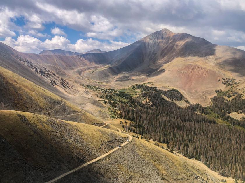
This photo shows Mount Antero’s summit on the far right, along with the switchbacks that continue to an alpine meadow.
The 4WD road eventually gets quite a bit steeper as travelers encounter a number of switchbacks. Now above treeline, stunning views surround the path as the road climbs through alpine meadow terrain and then (after a turn or two) to a rocky point at roughly 13,800-feet of elevation.
A hiker heads down a road beneath Mount Antero.
This is when the only true trail portion of this hike is found. Be warned, to summit this peak you’ll be traveling through active mining sites. This means that staying on route is crucial to your safety and respecting the rules of claimholders.
This photo shows the final approach toward the summit of Mount Antero, which is the only portion of the route that is class two terrain.
The scrambling portion of the climb to the summit is brief, class two terrain. It’s easy to follow a path to the summit as the top of the peak is clearly in view.
From the top, hikers see amazing views of the surrounding Collegiate Peaks and the nearby Cronin Peak, which is a few feet shy of being another fourteener.
Overall, I had low expectations going into my Mount Antero hike due to the lack of true trail. That being said, I throughly enjoyed the experience. The stunning views along the way and the workout of the long, steep climb made it worth it. Plus, a lot of the trail is great for running.
Perhaps the best aspect of this peak is that it offers hikers a chance to taste class two climbing with less commitment if they’re able to travel the 4WD road to the top. The multiple campsites and pull-offs found along Baldwin Gulch Jeep Road also allow hikers to customize the length of the trail to best fit the experience they’re looking for.
Follow along with more of Spencer’s adventures on Instagram at @spence.outside
This content was originally published here.

