The snowpack in Colorado is a very important number to monitor. It provides many Coloradans with their drinking water, water for ranchers and farmers and many bordering states also use the water that comes from the snow we get here in the Centennial State.
Sometimes, it’s hard to understand or visualize what a low or a high snowpack looks like, especially if you’re not from here, and thankfully, there are a lot of ways that we can visualize how our snowpack is doing – like looking at pictures.
The Colorado Department of Transportation has traffic cameras situated in some remote areas of Colorado, including mountain passes which rise above 11,000 feet in most cases. That puts these cameras in a good spot to view snowpack conditions. At even higher elevations, the Federal Aviation Administration recently installed cameras atop many 13,000-foot mountain top weather stations where they were already monitoring weather conditions. National Park cams and ski area cams also provide a useful vantage point for many mountain peaks.
With a year like this one where snowpack is extremely variable from one end of the state to the other, these cameras help to put into perspective what different levels of snowpack look like during May.
Here is what snowpack looks like across Colorado:
Coal Bank Pass – San Juan Mountains (~35% of normal snowpack)
Coal Bank Pass as seen on May 20, 2021.
Pretty much the only area that has a snowpack above alpine level in this area of the San Juans.
Wolf Creek Pass – San Juan Mountains (~40% of normal snowpack)
Snowpack is seen at Wolf Creek Pass on May 20, 2021.
Wolf Creek Pass looks better with some snow meandering down below the tree line but this is less than what is typically expected around this date.
Wilkerson Pass – Southwest Front Range Mountains (-65% of normal snowpack)
A look at Wilkerson Pass, as seen on May 20, 2021.
Looking north on Wilkerson Pass shows only a few peaks with snow on them as of May 20.
Aspen Highlands – Elk Mountains (~55% of normal snowpack)
A look at Maroon Bells from Aspen Highlands, on May 20, 2021.
This view from the top of Aspen Highlands facing the Maroon Bells shows that snowpack is looking decent for this time of the year. This is what ~55% snowpack looks like.
Monarch Pass – Sawatch Range (~65% of normal snowpack)
A look at Monarch Pass, as seen on May 20, 2021.
Monarch Pass and the surrounding area have benefitted slightly from the recent stretch of stormy weather.
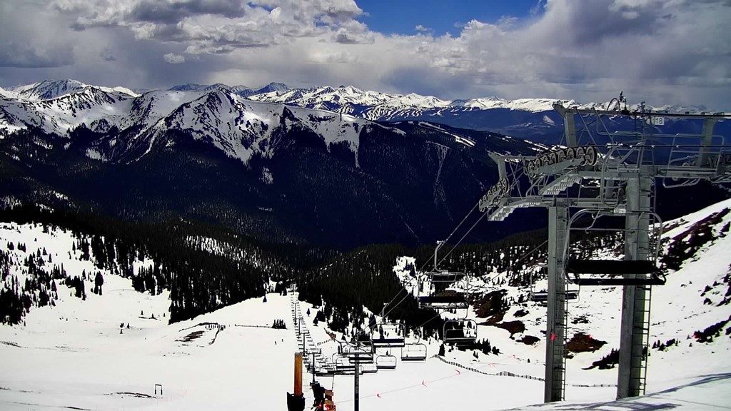
Arapahoe Basin – Front Range Mountains (~110% of normal snowpack)
A look at Arapahoe Basin, looking south, as seen on May 20, 2021.
They’re still skiing at A-Basin so snowpack has to be good up at The Legend.
Rocky Mountain National Park – N. Front Range Mountains (~120% of normal snowpack
A look at Rocky Mountain National Park, as seen on May 20, 2021.
Thanks to so many late season snowstorms, RMNP is faring extremely well in terms of snowpack.
With the hope of more wet weather on the horizon, maybe we can delay the completion of snowmelt in the southern and western portion of the state. In the central and northern tiers, snowpack is looking adequately healthy and hopefully that will help curb any drought impacts from re-forming in certain areas east of the Continental Divide.
This content was originally published here.

